Instead of taking the very busy touristy Route 132 back to the mainland, I went back to the town of Gaspe at the peaceful hospital parking lot . . .
. . . so I could get an early start in the morning to drive on the inland mountain road that would eventually meet up with Route 132. It was a wonderful drive. I was almost the sole vehicle on this 82-mile mountainous stretch. The closer I got to the Gulf of Saint Lawrence, the foggier it got.
This 82 mile stretch has only one town, a company town of sorts.
Murdochville, started by Mr. Murdoch of course, is a mining town. From raw ore, pure copper anode is produced. Their town's statue is a good one.
When I joined up with Route 132, there were constant wonderful views of the Gulf of Saint Lawrence.
For no reason at all, I spent the night downtown Rimouski, a large town with a lot of activity, plus a bike and pedestrian promenade along the Gulf which beckoned me. A local man there told me I could park all night downtown. When I woke up early Sunday morning, I took advantage of the sleepy-eyed town and began a bike tour on the promenade along the Gulf. Even the seagulls were still sleeping.
On the Gulf is a marshy protected area for wildlife.
I rode by a closed museum that tells the story of the disastrous sinking of the Empress of Ireland in 1914 when 1,012 people died in the Gulf of Saint Lawrence. I liked their statue in the front.
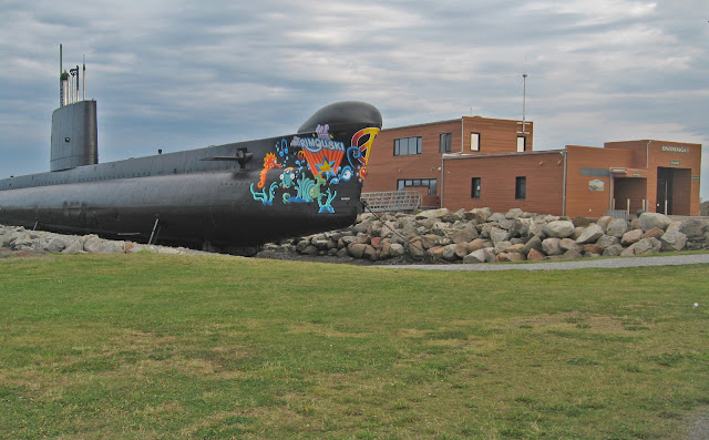
Also rode by this submarine (closed when I was there), named "Onondaga" (click here for link telling the interesting story).
I'm not big on lighthouses, but this one (built in 1867) has an interesting story. Click here for story. The part of the story I like is the fact that at this point, navigation on this body of water is both river and sea navigation. It's sort of the turning point from the Saint Lawrence River to the Gulf of Saint Lawrence.
After the enjoyable bike ride, I reluctantly joined up with the tourists again on Route 132 only to be easily distracted in a short while by some water activity going on in the Gulf. Turns out, a group of kayakers are assembling and are waiting for the tide to come in.
Back on the road again . . .
I'm now beginning to see the north side of the river.
And the weather is fickle here, too.
Sprinkle or two . . . wildflowers love it.
Interesting rocky islands in the river.
Notice the crops? Route 132 lies between the river, a stretch of farmland with crops and dairy farms, and a mountain range on the other side. It was a wonderfully scenic drive, and since the tourists were now on the National Highway 20 (high speed lanes), I now had Route 132 to myself most of the time.
Have been enjoying driving 25 mph through all the little cute villages on Route 132, most of which have an old church with two tall steeples. Reminds me of French country villages when I was in France a couple years ago. Here's a few shots of the colorful cottages.
While there are lots of muted pastel painted cottages, it seems half are muted and the other half are painted a vivid color. Probably reflects its citizens, half want to blend in un-noticed and the other half want to stand out in the crowd.
I'm not in a big hurry to leave this area by the way. Has everything I love to do, hiking, paddling, biking . . . .


No comments:
Post a Comment