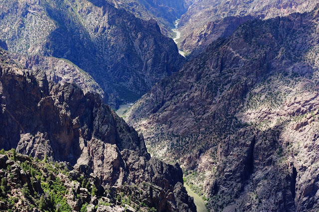
Officially known as "Black Canyon of the Gunnison (River) National Park", this park had 238,018 visitors last year. To give a perspective, Bryce Canyon had 2.3 million visitors last year. I don't like crowds, so this park was perfect to visit.
Like the Grand Canyon, it has a south rim and a north rim. The drive to the South Rim was initially on a dirt road.
The snowy Colorado Mountains are everywhere!
The canyon is deceptively hidden. In this photo below, the foreground is the Rim Rock Trail on the south rim where I was walking. The background, upper half of photo, is the north rim. See the North Rim Dirt Road? It's closed during winter months.
But there's a canyon there in the middle!
After setting up camp at the South Rim Campground, I walked about one mile on the Rim Rock Trail to the Visitor Center where there is an outlook.
At the outlook, I'm astonished at how deep it is; the canyon's average depth is 2,000 feet straight down. This is not a good park to visit if you suffer from vertigo.
I hiked the Uplands Trail back to the campground. All the trails were easy; didn't need to wear boots.
The best way to appreciate this vast dark deep canyon is to visit each lookout point along the 7 mile South Rim Road. To make it more fun, I rode my electric bike (mostly uphill) to each point, starting at the South Rim Campground and working my way counter-clockwise to "High Point".
There are very limited casual recreational uses here! Not even the Ute Indians explored the canyon. But several hardy brave souls tried to explore this river (click here for short list). The most thrilling exploration is Abraham Lincoln Fellows' 1901 expedition (click here for that story).
I talked with a ranger who was looking below with binoculars. He was checking on the 9 people who had special permits to hike below. The limit is 15 people daily.
It's hard to photograph this vast canyon. See the patch of trees next to the needle-like plateau, upper left?
Here's a zoomed-in look at that patch of trees; they're probably 20 feet tall.
A most welcomed small pool of water for wildlife.
Trees struggle here.
Cedar Point is beautiful.
Twisting . . .
and competing for life.
The Painted Wall, another sight along the South Rim Road, is the tallest vertical wall in the state of Colorado, rising 2,250 feet high. I couldn't get it all in one photo!
A better attempt at it . . .
Another attempt.
For perspective, the 2,250 foot Painted Wall is almost twice as high as the Empire State Building.
The Gunnison River is classified as Class V . . . .
. . . and way beyond, unnavigable! Have never seen such a frothy river.
Here's what the river sounds like from 2,000 feet above it.
The Black Canyon gets very little light.
I tried a panoramic photo, but it doesn't give a true perspective of the canyon's magnitude.
This handsome little guy with yellow toes is a collared lizard.
Beauty among the beastly boulders.
The "Warner Point" hike (1.5 miles, more suitable for boots and poles, several ups/downs, highest elevation is 8,293 feet) offers a dual view. To the north, the 2,700 foot deep Black Canyon, and to the south, a valley (photo below) that is irrigated by the Gunnison River.
See the three people hiking in front of me on the Warner Point Trail?
In a lively conversation, I discovered they lived in the Houston area; he worked for Exxon as an engineer. They've been married 50 years and are triple-citizens (England initially, then Canada and the United States). His job took him to Colombia, Nigeria, El Salvador, to name a few countries. Eighteen years ago (he's 73 now, his wife is 69), when he was 55 years old, he retired due to stress in his job, vowing not to die of a heart attack at 55 years like his father did. But surprise, surprise, two weeks before his retirement day, he had a heart attack! He recovered and they eventually moved away from Houston and the hustle-bustle of the city. They now live nearby the Black Canyon in Montrose. Her brother (in the middle of photo, he's 66 years old) was visiting from England. It was fun meeting these friendly "local" folks.
Back at High Point after the Warner Point hike, I begin my bike ride "home" to the South Rim Campground. It's already been a long day, about six hours of hiking and uphill biking to all the points, perhaps six miles total hiking and seven miles biking one way. But the seven mile bike ride to my campsite was my Big Adventure!
Google Map calculates it would take 47 minutes to ride back to the campsite, but I did it in about 15 minutes, and more than half of it without using my electric motor. See all the curves in that road? That exhilarating very scenic ride mostly downhill will be a life-long vivid memory!


No comments:
Post a Comment